New Zealand
English
Type and search...

Sold: $2,260,000

Sold on 2023 Year 2023 Month 09 Day 20

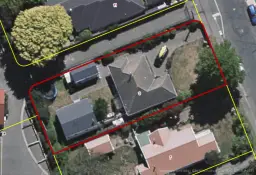
5 Peel Street, Strowan, Christchurch

4
293m2
809m2

Council Data

Last update : 2024 06 19
Improvement value$1,110,000Increased by 30% from year 2019
Land value$1,290,000Increased by 69% from year 2019
CV(Year 2022 Month 08)$2,400,000Increased by 49% from year 2019
DeckYes
View typeNo appreciable view
ContourLevel
Land area809m²
Floor area293m²
Decade of construction2010
TitleCB344/287
Type of titleFreehold
Legal descriptionLOT 19 DP 3429
CouncilChristchurch
Estate descriptionFSIM,1/1,LOT 19 DEPOSITED PLAN 3429,809m2
ConstructionExternal Walls: Wood Roof: Iron
ConditionExternal Walls: Good Roof: Good
ZoningResidential Suburban

School zones

Name
Distance
Type
Year
Attribute
Gender
Score
Decile
St Patrick's School (Bryndwr)
0.43 km
Primary
1-8
Government
Co-Educational
EQI: 379
10
Heaton Normal Intermediate
0.51 km
Secondary
7-8
Government
Co-Educational
EQI: 404
9
Elmwood Normal School
0.62 km
Primary
1-6
Government
Co-Educational
EQI: 377
10
Christchurch Adventist School
1.24 km
Combined
1-13
Government
Co-Educational
EQI: 438
5
Christchurch Girls' High School -Te Kura o Hine Waiora
1.59 km
Secondary
9-15
Government
Single Sex-Girls
EQI: 411
9
Christchurch Boys' High School
1.85 km
Secondary
9-15
Government
Single Sex-Boys
EQI: 413
10
Burnside High School
2.55 km
Secondary
9-15
Government
Co-Educational
EQI: 418
8
Christ The King School (Burnside)
2.62 km
Primary
1-8
Government
Co-Educational
EQI: 370
8
Te Puna Wai o Waipapa - Hagley College
3.22 km
Secondary
9-15
Government
Co-Educational
EQI: 472
6
Emmanuel Christian School
3.87 km
Combined
1-10
Government
Co-Educational
EQI: 419
8
Villa Maria College
3.92 km
Secondary
7-15
Government
Single Sex-Girls
EQI: 407
9
Middleton Grange School
3.92 km
Combined
1-13
Government
Co-Educational
EQI: 406
9
Marian College
4.39 km
Secondary
9-15
Government
Single Sex-Girls
EQI: 434
8
St Thomas of Canterbury College
5.01 km
Secondary
7-15
Government
Single Sex-Boys
EQI: 427
8

Property history

Need Login
Please login

For developers

Unitary plan:Residential Suburban
Land:809m²
Title:Freehold
Zoning
Underground
Contour
State houses
Flood zone

Mortgage

Sold nearby

Address
Distance
Bed
Bath
Floor area
Sold date
Sold
Data source
0.26 km
3
173m2
Year 2024 Month 05 Day 03
$1,235,000
Council approved
0.18 km
3
137m2
Year 2024 Month 04 Day 29
$680,000
Council approved
18A Strowan Road
0.32 km
2
1
-m2
Year 2024 Month 03 Day 25
$669,000
Council approved
9 Orkney Street
0.26 km
3
138m2
Year 2024 Month 03 Day 04
$880,000
Council approved
83 Saint Andrews Square
0.27 km
4
2
210m2
Year 2024 Month 02 Day 01
$1,915,000
Council approved

You may like

Last update:-