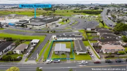
2965 Main South Road, Burnham, Selwyn
3
120m2
62853m2
Council Data
Last update : 2024 07 03
Improvement value$545,000Reduced by 0% from year 2021
Land value$295,000Reduced by 0% from year 2021
CV(Year 2021 Month 09)$840,000Reduced by 0% from year 2021
View type
Contour
Land area
Floor area
Decade of construction
Title
Type of title
Legal description
Council
Estate description
Construction
Condition
Zoning
School zones
Property history
Please login
For developers
Unitary plan:Outer Plains
Land:62853m²
Title:Freehold