
Play


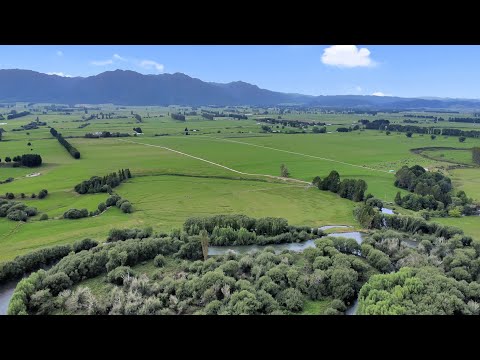
Located within the picturesque Galatea Valley is this 129.6130 hectares (more or less) dairy farm consisting of three titles. 121 hectares of the property forms the milking platform with a 3-year average production of 127,000 kg/ms from 300 cows with all cows being wintered on farm. 86 hectares of the property is covered with irrigation with 58.5 hectares under a Centre Pivot with the remaining 27.5 hectares covered with a Bosch Lateral system. Farm Infrastructure includes a modern 30 aside herringbone shed with 300 cow yard capacity, a vast array of farm shedding including a near new implement shed/workshop. The property will also come complete with a newly consented effluent system complete with a 300 cubic metre bladder. Housing is catered for via two good 3-bedroom homes complete with detached double garaging, with the main dwelling being only recently built. Our downsizing vendors are offering the property for sale with the option of being able to purchase all plant, machinery and stock on a going concern basis.
Address | Distance | Bed | Bath | Floor area | Sold date | Sold | Data source | |
|---|---|---|---|---|---|---|---|---|
 | 6.27 km | 3 | 1 | 102m2 | Year 2024 Month 11 Day 13 | $165,000 | Council approved | |
 | 6.12 km | 2 | 1 | 100m2 | Year 2024 Month 11 Day 01 | $102,000 | Council approved | |
 | 6.58 km | 3 | 1 | 95m2 | Year 2024 Month 10 Day 25 | $232,000 | Council approved | |
 | 5.92 km | 3 | 1 | 90m2 | Year 2024 Month 10 Day 02 | $206,000 | Council approved | |
 | 0.68 km | 1 | 1 | 70m2 | Year 2024 Month 08 Day 06 | - | Council approved |