
Video abspielen


For the next generation of eco entrepreneurs, stargazers, lifestylers, dreamers... and me.
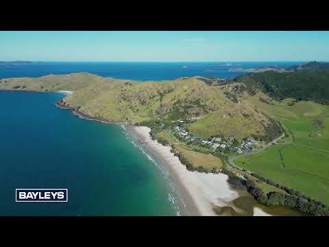
Do you want a place to park up for the rest of your life that has an extra string to its bow? Yes, then this is just the place for you. Pictured above is a large block overlooking Otama Beach and Estuary, with views right up to Cape Colville, Great Barrier Island and the Mercury Islands.
And the extra string to its bow? The property has a structure plan in place to create 10 titles from it's 103.1973ha (more or less), which is optional if you want to keep the land all to yourself. The land continues its 60-year reign as a productive grazing and fattening beef property, with flat to rolling pasture and some steeper sidling's. With a good water supply, various soil types (some of which could support horticulture), fencing and farm roading in place.
The opportunities for new owners are endless. Indulge in local fishing, surfing, swimming and tramping activities right on your doorstep. Enjoy being part of the communities of Matarangi, Kuaotunu, Otama and Opito Bay. Whitianga is a just a 30-minute drive to the east, while Coromandel Town is 35 minutes to the west.
And me? The owner is retiring and releasing this special piece of land to the next generation of custodians to follow their vision. Calling all eco entrepreneurs, stargazers, lifestylers and dreamers to make this connection!
Straßenadresse | Entfernung | Anzahl der Schlafzimmer | Anzahl der Badezimmer | Gebäudefläche | Verkaufsdatum | Verkaufspreis | Datenquelle | |
|---|---|---|---|---|---|---|---|---|
 | 13.78 km | 3 | 1 | -m2 | 2024 Jahr 12 Monat 06 Tag | $950,000 | Council approved | |
 | 0.42 km | 3 | 3 | -m2 | 2024 Jahr 12 Monat 04 Tag | $1,115,000 | Council approved | |
 | 0.89 km | 3 | 1 | -m2 | 2024 Jahr 11 Monat 27 Tag | $655,000 | Council approved | |
 | 12.95 km | 0 | 0 | 0m2 | 2024 Jahr 10 Monat 30 Tag | $406,000 | Council approved | |
 | 13.31 km | -m2 | 2024 Jahr 07 Monat 11 Tag | $405,000 | Council approved |